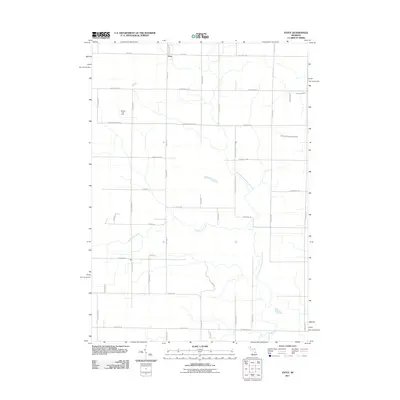
2011 Map of Estey
USGS Topo · Published 2011About this map
Estey serves as a central point in this rural section of Michigan, where the landscape is defined by the headwaters of several regional waterways. The map illustrates a grid-heavy road network typical of the Midwest, punctuated by the Bentley Oil Field in the west, indicating the area's history with resource extraction. This 2011 survey reveals the hydrological importance of the region, as the North Branch Kawkawlin River and Kawkawlin Creek wind southward through the terrain. The presence of significant boundaries like Bay Glad County Line Rd and N Bay Mid County Line Rd shows how political geography often follows the practical placement of local infrastructure. To the north and east, the South Branch Pinconning River and Pinconning River further emphasize the drainage patterns that have shaped the development and agricultural layout of this township.
Find a feature on this map
45 named features on this map. Tap any name to fly to it.
Don’t see what you’re looking for? This feature index may not catch every label — zoom into the map to look around manually.
Map Details
Editions of this 2011 Estey Map
This is the sole edition of this map. No revisions or reprints were ever made.
Other maps of this area

1934 · Sanford
USGS Topo · 1:62,500

1936 · Sanford
USGS Topo · 1:62,500

1954 · Midland
USGS Topo · 1:250,000

1958 · Midland
USGS Topo · 1:250,000

1959 · Midland
USGS Topo · 1:250,000

1962 · Willard
USGS Topo · 1:24,000

1962 · Midland North
USGS Topo · 1:24,000

1966 · Midland
USGS Topo · 1:250,000
1967 · Mount Forest
USGS Topo · 1:24,000
1967 · Crump
USGS Topo · 1:24,000