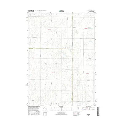
2017 Map of Estey
USGS Topo · Published 2017About this map
Estey serves as the focal point of this low-lying area near the intersection of Gladwin, Bay, and Midland counties. The landscape is defined by a dense network of water management features, reflecting a history of drainage projects necessary for agricultural and residential development in this part of Michigan. Major natural waterways like the Pinconning River and the N Br Kawkawlin River are augmented by numerous named channels, including Chubb Drain, Wright Drain, and Herner Drain. The layout of the road network, such as Estey Rd and Pinconning Rd, follows the rigid section lines of the Public Land Survey System, while the meandering paths of Kawkawlin Cr and its various branches create the only deviations from this geometric grid. This detailed survey provides a clear view of the rural infrastructure and hydraulic modifications that shaped the region by the early 21st century.
Find a feature on this map
61 named features on this map. Tap any name to fly to it.
Don’t see what you’re looking for? This feature index may not catch every label — zoom into the map to look around manually.
Map Details
Editions of this 2017 Estey Map
This is the sole edition of this map. No revisions or reprints were ever made.
Other maps of this area

1934 · Sanford
USGS Topo · 1:62,500

1936 · Sanford
USGS Topo · 1:62,500

1954 · Midland
USGS Topo · 1:250,000

1958 · Midland
USGS Topo · 1:250,000

1959 · Midland
USGS Topo · 1:250,000

1962 · Willard
USGS Topo · 1:24,000

1962 · Midland North
USGS Topo · 1:24,000

1966 · Midland
USGS Topo · 1:250,000
1967 · Mount Forest
USGS Topo · 1:24,000
1967 · Crump
USGS Topo · 1:24,000