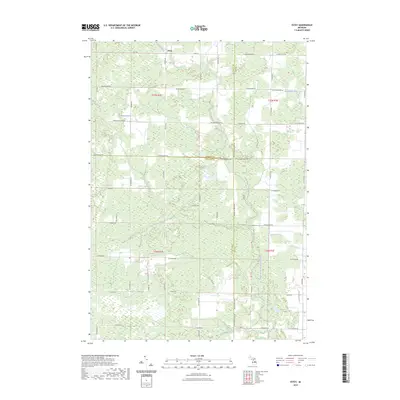
2023 Map of Estey
USGS Topo · Published 2023About this map
Estey serves as a central point of reference in this landscape at the intersection of Gladwin, Midland, and Bay counties. The terrain is defined by an extensive drainage network, where the headwaters of the North Branch Kawkawlin River and the Pinconning River begin their transit across the flat woodland and agricultural parcels. The intricate system of waterways, including Chubb Drain, Kawkawlin Creek, and Wright Drain, illustrates the intensive land management required in this part of Michigan to support the rural road grid. Boundary lines for T17N R2E and T16N R3E provide precise locations for genealogists and local historians tracking family land tracts. This 2023 survey by the U.S. Geological Survey documents the modern configuration of section lines and township roads such as Pinconning Rd and Townline 16 Rd that have organized the region since its early settlement.
Find a feature on this map
61 named features on this map. Tap any name to fly to it.
Don’t see what you’re looking for? This feature index may not catch every label — zoom into the map to look around manually.
Map Details
Editions of this 2023 Estey Map
This is the sole edition of this map. No revisions or reprints were ever made.
Other maps of this area

1934 · Sanford
USGS Topo · 1:62,500

1936 · Sanford
USGS Topo · 1:62,500

1954 · Midland
USGS Topo · 1:250,000

1958 · Midland
USGS Topo · 1:250,000

1959 · Midland
USGS Topo · 1:250,000

1962 · Willard
USGS Topo · 1:24,000

1962 · Midland North
USGS Topo · 1:24,000

1966 · Midland
USGS Topo · 1:250,000
1967 · Mount Forest
USGS Topo · 1:24,000
1967 · Crump
USGS Topo · 1:24,000