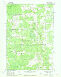
1969 Map of Estey
USGS Topo · Published 1972About this map
Bentley State Forest and Mount Forest dominate this landscape on the border of Gladwin, Midland, and Bay counties as it appeared in the late 1960s. The small settlement of Estey sits near the northern edge, serving as a focal point in a region defined by its drainage systems and timber history. An Old Railroad Grade cutting through the forest provides a clear trace of the area's earlier logging economy, showing how former transit corridors shaped the local geography.
Find a feature on this map
38 named features on this map. Tap any name to fly to it.
Don’t see what you’re looking for? This feature index may not catch every label — zoom into the map to look around manually.
Map Details
Editions of this 1969 Estey Map
This is the sole edition of this map. No revisions or reprints were ever made.
Other maps of this area

1934 · Sanford
USGS Topo · 1:62,500

1936 · Sanford
USGS Topo · 1:62,500

1954 · Midland
USGS Topo · 1:250,000

1958 · Midland
USGS Topo · 1:250,000

1959 · Midland
USGS Topo · 1:250,000

1962 · Willard
USGS Topo · 1:24,000

1962 · Midland North
USGS Topo · 1:24,000

1966 · Midland
USGS Topo · 1:250,000
1967 · Mount Forest
USGS Topo · 1:24,000
1967 · Crump
USGS Topo · 1:24,000