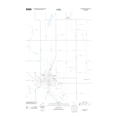
2013 Map of Estherville
USGS Topo · Published 2013About this map
The Des Moines River winds through the heart of northern Emmet County, anchoring the city of Estherville and its surrounding agricultural landscape. This survey illustrates the town's grid-pattern expansion along the riverbanks, where the Fourth Street Bridge provides a primary crossing point between the north and south sectors of the community. Beyond the city limits, the terrain is defined by a series of drainage works including Ditch Number 79 and Ditch Number 7, which support the intensive farming characteristic of this region. To the north, the small settlement of Huntington sits near the headwaters of local tributaries, while Eagle Lake remains a significant natural basin. The presence of the Riverside Hills Ski Area and the Estherville Municipal Airport highlights the area's modern development as both a regional hub and a recreational destination.
Find a feature on this map
89 named features on this map. Tap any name to fly to it.
Don’t see what you’re looking for? This feature index may not catch every label — zoom into the map to look around manually.
Map Details
Editions of this 2013 Estherville Map
This is the sole edition of this map. No revisions or reprints were ever made.
Other maps of this area

1954 · Fairmont
USGS Topo · 1:250,000

1958 · Fairmont
USGS Topo · 1:250,000

1970 · Ceylon
USGS Topo · 1:24,000

1970 · Jackson
USGS Topo · 1:24,000

1970 · Dunnell
USGS Topo · 1:24,000

1972 · Terril
USGS Topo · 1:24,000

1972 · Wallingford
USGS Topo · 1:24,000

1972 · Estherville
USGS Topo · 1:24,000
1972 · Superior
USGS Topo · 1:24,000

1980 · Ingham Lake
USGS Topo · 1:24,000