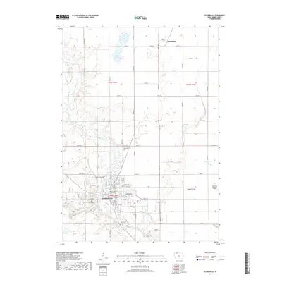
2018 Map of Estherville
USGS Topo · Published 2018About this map
The Des Moines River winds through the heart of Estherville, defining the local geography as it flows south toward the Fourth Street Bridge. This area of Emmet County shows a developed grid of town streets and rural section lines, including the northern settlement of Huntington. The landscape is dotted with community heritage sites, particularly a high concentration of cemeteries such as Estherville Lutheran Cem, Norwegian Cem, and Saint Patrick's Catholic Cem. To the east, Brown Cr and several drainage systems like Ditch Number 7 manage the prairie hydrology, while the Estherville Municipal Airport and Eagle Lake mark the transitions between the town's industrial edge and the surrounding agricultural tracts. The map provides a clear record of the intersection between civic infrastructure and the river valley's natural contours.
Find a feature on this map
38 named features on this map. Tap any name to fly to it.
Don’t see what you’re looking for? This feature index may not catch every label — zoom into the map to look around manually.
Map Details
Editions of this 2018 Estherville Map
This is the sole edition of this map. No revisions or reprints were ever made.
Other maps of this area

1954 · Fairmont
USGS Topo · 1:250,000

1958 · Fairmont
USGS Topo · 1:250,000

1970 · Ceylon
USGS Topo · 1:24,000

1970 · Jackson
USGS Topo · 1:24,000

1970 · Dunnell
USGS Topo · 1:24,000

1972 · Terril
USGS Topo · 1:24,000

1972 · Wallingford
USGS Topo · 1:24,000

1972 · Estherville
USGS Topo · 1:24,000
1972 · Superior
USGS Topo · 1:24,000

1980 · Ingham Lake
USGS Topo · 1:24,000