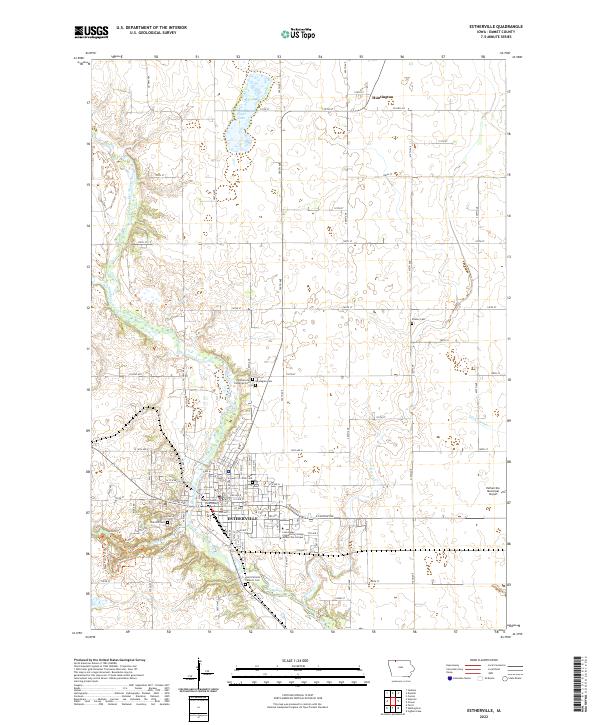
2022 Map of Estherville
USGS Topo · Published 2022About this map
Estherville serves as the focal point of this northern Iowa landscape, situated along the winding course of the Des Moines River. The town's administrative and educational importance is grounded by the Emmet County Courthouse and the Iowa Lakes Community College Estherville Campus. To the north, the small settlement of Huntington sits near the Minnesota border, surrounded by a grid of agricultural section lines and drainage features like Eagle Lake and Ditch Number 79.
Find a feature on this map
47 named features on this map. Tap any name to fly to it.
Don’t see what you’re looking for? This feature index may not catch every label — zoom into the map to look around manually.
Map Details
Editions of this 2022 Estherville Map
This is the sole edition of this map. No revisions or reprints were ever made.
Other maps of this area

1954 · Fairmont
USGS Topo · 1:250,000

1958 · Fairmont
USGS Topo · 1:250,000

1970 · Ceylon
USGS Topo · 1:24,000

1970 · Jackson
USGS Topo · 1:24,000

1970 · Dunnell
USGS Topo · 1:24,000

1972 · Terril
USGS Topo · 1:24,000

1972 · Wallingford
USGS Topo · 1:24,000

1972 · Estherville
USGS Topo · 1:24,000
1972 · Superior
USGS Topo · 1:24,000

1980 · Ingham Lake
USGS Topo · 1:24,000