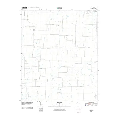
2010 Map of Ethel
USGS Topo · Published 2010About this map
Ethel and Macomb stand as small agricultural hubs in the northern Texas prairie at the start of the 21st century. This landscape in Grayson County is defined by a dense network of county roads and a significant petroleum footprint, seen in the Mackoy Oil Field, Hester Oil Field, and Collinsville Oil Field. Water management is central to the area's geography, with the Touchstone Lake Dam and Gressett Lake Dam regulating local drainages. Genealogists will find particular value in the several documented burial sites that anchor these small communities, including Ethel Cemetery, Macomb Cemetery, and the Walthall Cemetery to the west. The drainage patterns of Hog Creek, Case Creek, and Range Creek carve through the flatlands, illustrating how the natural topography dictates the placement of rural farmsteads and the winding paths of roads like Old Sanborn Ranch Rd.
Find a feature on this map
59 named features on this map. Tap any name to fly to it.
Don’t see what you’re looking for? This feature index may not catch every label — zoom into the map to look around manually.
Map Details
Editions of this 2010 Ethel Map
This is the sole edition of this map. No revisions or reprints were ever made.
Other maps of this area

1901 · Denison
USGS Topo · 1:125,000

1954 · Sherman
USGS Topo · 1:250,000

1958 · Dorchester
USGS Topo · 1:24,000

1958 · Sherman NW
USGS Topo · 1:24,000

1958 · Whitesboro
USGS Topo · 1:62,500

1958 · Sherman
USGS Topo · 1:250,000

1958 · Sherman
USGS Topo · 1:62,500

1961 · Gunter
USGS Topo · 1:24,000

1961 · Pilot Point
USGS Topo · 1:24,000
1961 · Marilee
USGS Topo · 1:24,000