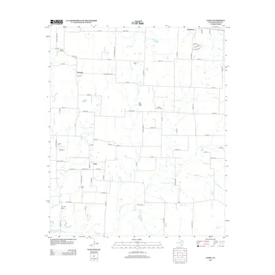
2013 Map of Ethel
USGS Topo · Published 2013About this map
Ethel and Macomb stand as primary rural hubs in this portion of Grayson County, where the landscape is defined by a dense network of country roads and intermittent creeks. This 2013 survey illustrates the area's ongoing reliance on petroleum extraction and aviation, evidenced by the Collinsville Oil Field, Mackay Oil Field, and Hester Oil Field scattered across the township lines. Private aviation is notably prominent with the presence of J-Bar Ranch Airport and Flying S Ranch Airport. For genealogists, the map preserves the exact locations of several local burial grounds, including the Ethel Cemetery, Macomb Cemetery, and Walthall Cemetery. The drainage patterns of Hog Creek and Case Creek provide a clear view of the natural topography that influenced early settlement and road placement in this North Texas region.
Find a feature on this map
80 named features on this map. Tap any name to fly to it.
Don’t see what you’re looking for? This feature index may not catch every label — zoom into the map to look around manually.
Map Details
Editions of this 2013 Ethel Map
This is the sole edition of this map. No revisions or reprints were ever made.
Other maps of this area

1901 · Denison
USGS Topo · 1:125,000

1954 · Sherman
USGS Topo · 1:250,000

1958 · Dorchester
USGS Topo · 1:24,000

1958 · Sherman NW
USGS Topo · 1:24,000

1958 · Whitesboro
USGS Topo · 1:62,500

1958 · Sherman
USGS Topo · 1:250,000

1958 · Sherman
USGS Topo · 1:62,500

1961 · Gunter
USGS Topo · 1:24,000

1961 · Pilot Point
USGS Topo · 1:24,000
1961 · Marilee
USGS Topo · 1:24,000