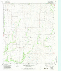
1982 Map of Ethel
USGS Topo · Published 1983About this map
Ethel and Southmayd anchor this early 1980s landscape of the Texas blackland prairies, where the economy was defined by a mix of agriculture and energy extraction. The map reveals the extensive industrial footprint of the Mackoy Oil Field and the Hester Oil Field, characterized by numerous Oil Wells and a network of lease roads. For genealogists, the map provides precise locations for several family and community burial grounds, including the Old Pioneer Cem, Macomb Cem, and Walthall Cem, often found adjacent to the winding course of Spring Creek. This period in Grayson County history shows the persistence of small rural hubs like Bucktussle amidst the expanding oil infrastructure and long-established farmstead property lines.
Find a feature on this map
13 named features on this map. Tap any name to fly to it.
Don’t see what you’re looking for? This feature index may not catch every label — zoom into the map to look around manually.
Map Details
Editions of this 1982 Ethel Map
This is the sole edition of this map. No revisions or reprints were ever made.
Other maps of this area

1901 · Denison
USGS Topo · 1:125,000

1954 · Sherman
USGS Topo · 1:250,000

1958 · Dorchester
USGS Topo · 1:24,000

1958 · Sherman NW
USGS Topo · 1:24,000

1958 · Whitesboro
USGS Topo · 1:62,500

1958 · Sherman
USGS Topo · 1:250,000

1958 · Sherman
USGS Topo · 1:62,500

1961 · Gunter
USGS Topo · 1:24,000

1961 · Pilot Point
USGS Topo · 1:24,000
1961 · Marilee
USGS Topo · 1:24,000