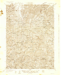
1931 Map of Etna
USGS Topo · Published 1931About this map
Scott Valley and the northern reaches of the Scott River define this 1931 survey of the California gold country. The landscape is heavily marked by the region's extraction history, featuring numerous family-operated and commercial claims like the Bonanza King Mine, Integral Mine, and the Society Girl Mine. Scattered settlements such as Callahan, Carrville, and Trinity Center anchor the valley and river forks, connected by early roads that navigated the steep terrain between Scott Mountain and Mount Eddy.
Find a feature on this map
171 named features on this map. Tap any name to fly to it.
Don’t see what you’re looking for? This feature index may not catch every label — zoom into the map to look around manually.
Map Details
Editions of this 1931 Etna Map
This is the sole edition of this map. No revisions or reprints were ever made.
Other maps of this area

1886 · Shasta
USGS Topo · 1:250,000

1890 · Red Bluff
USGS Topo · 1:250,000

1894 · Red Bluff
USGS Topo · 1:250,000

1894 · Shasta
USGS Topo · 1:250,000
1901 · Redding
USGS Topo · 1:125,000
1909 · Big Bar
USGS Topo · 1:96,000
1913 · Weaverville
USGS Topo · 1:125,000
1914 · Seiad
USGS Topo · 1:125,000
1915 · Big Bar and Vicinity
USGS Topo · 1:250,000
1921 · Shasta Valley Sheet No 7
USGS Topo · 1:24,000