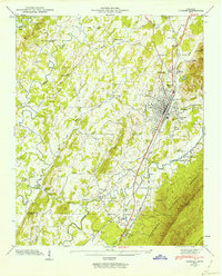
1943 Map of Etowah
USGS Topo · Published 1960About this map
The Louisville and Nashville railroad corridor serves as the industrial and social spine of this Tennessee landscape, anchoring the significant rail town of Etowah and its surrounding communities. The grid of the town is densely packed with residential blocks and key local landmarks like North Etowah Sch and the Etowah Water Works. Further south, the landscape transitions into the agricultural and industrial hub of Delano, complete with its own Delano Sta and nearby Delano Cem.
Find a feature on this map
61 named features on this map. Tap any name to fly to it.
Don’t see what you’re looking for? This feature index may not catch every label — zoom into the map to look around manually.
Map Details
Editions of this 1943 Etowah Map
2 editions found
Other maps of this area

1886 · Cleveland
USGS Topo · 1:125,000

1892 · Cleveland
USGS Topo · 1:125,000

1893 · Murphy
USGS Topo · 1:125,000

1895 · Cleveland
USGS Topo · 1:125,000

1901 · Cleveland
USGS Topo · 1:125,000

1914 · Murphy
USGS Topo · 1:125,000

1934 · Mecca
USGS Topo · 1:24,000

1934 · Englewood
USGS Topo · 1:24,000

1935 · Tellico
USGS Topo · 1:48,000

1935 · Calhoun
USGS Topo · 1:24,000