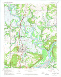
1963 Map of Eufaula
USGS Topo · Published 1974About this map
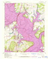
Eufaula serves as the focal point of this McIntosh County landscape, situated at a critical juncture of land and water transport in the early 1960s. The town's grid is defined by the Missouri-Kansas-Texas railroad corridor, while the eastern and southern reaches are dominated by the rising waters of Lake Eufaula. This map illustrates a significant period of transition for the region, where the original courses of the North Canadian River and the Deep Fork are shown alongside blue hatched lines indicating areas designated for submergence. Local history is deeply embedded in the rural surroundings through several family and community landmarks, including McIntosh Cem, Evergreen Cem, and Lawson Williams Cem. Small congregational hubs like West Eufaula Ch and Okfuskee Ch anchor the outlying settlements, while the presence of a Fish Hatchery and Baptizing Creek reflect the area's long-standing relationship with its river systems.
Find a feature on this map
23 named features on this map. Tap any name to fly to it.
Don’t see what you’re looking for? This feature index may not catch every label — zoom into the map to look around manually.
Map Details
Editions of this 1963 Eufaula Map
3 editions found
Other maps of this area

1900 · Sansbois
USGS Topo · 1:125,000

1900 · Canadian
USGS Topo · 1:125,000

1909 · Sans Bois
USGS Topo · 1:125,000

1911 · Sansbois
USGS Topo · 1:125,000

1946 · Fort Smith
USGS Topo · 1:250,000

1962 · Pierce
USGS Topo · 1:24,000

1963 · Warner NW
USGS Topo · 1:24,000

1963 · Stidham
USGS Topo · 1:24,000

1963 · Eufaula
USGS Topo · 1:24,000

1963 · Checotah
USGS Topo · 1:24,000