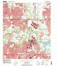
1995 Map of Euless
USGS Topo · Published 2002About this map
The West Fork Trinity River winds through the center of this Mid-Cities landscape, marking the transition between the dense residential development of Euless and the massive infrastructure of the Dallas - Fort Worth International Airport. Significant land modification is evident south of the river, where a series of Former Gravel Pits and industrial substations neighbor the expanding limits of Fort Worth and Arlington. Local history is preserved in several small burial grounds such as Bear Creek Cem and Colloway Cem, which sit in contrast to modern landmarks like the Ballpark at Arlington and the Amusement Park. This survey captures a moment of intense urban convergence where the corporate boundaries of several major North Texas cities meet, connected by the high-volume corridor of the International Parkway.
Find a feature on this map
62 named features on this map. Tap any name to fly to it.
Don’t see what you’re looking for? This feature index may not catch every label — zoom into the map to look around manually.
Map Details
Editions of this 1995 Euless Map
This is the sole edition of this map. No revisions or reprints were ever made.
Other maps of this area

1891 · Dallas
USGS Topo · 1:125,000

1893 · Dallas
USGS Topo · 1:125,000

1894 · Fort Worth
USGS Topo · 1:125,000

1925 · Dallas 2-b
USGS Topo · 1:48,000

1931 · Carrollton
USGS Topo · 1:62,500

1931 · Grapevine
USGS Topo · 1:62,500

1954 · Dallas
USGS Topo · 1:250,000

1958 · Dallas
USGS Topo · 1:250,000

1959 · Kennedale
USGS Topo · 1:24,000

1959 · Arlington
USGS Topo · 1:24,000