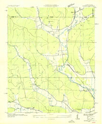
1936 Map of Eureka
USGS Topo · Published 1936About this map
The John Sumach Reservation sits prominently along the state line in this 1936 survey, where the Cumberland Plateau drops into the deep coves of Jackson County. This landscape is defined by the winding paths of Little Crow Creek and Coon Creek, which provided the flat land necessary for small communities to take root before the mid-century. The map captures a rural economy revolving around local commerce and faith, evidenced by sites like Brisco Store, Wynn Store, and Centennial Ch. Educational life is well-documented through a network of small schoolhouses, including Pleasant Grove Sch and White House Sch. The presence of Allison Mill and several family burial grounds, such as Allen Cem and Longacre Cem, offers significant detail for those researching the early 20th-century settlement patterns of the Alabama-Tennessee borderlands.
Find a feature on this map
52 named features on this map. Tap any name to fly to it.
Don’t see what you’re looking for? This feature index may not catch every label — zoom into the map to look around manually.
Map Details
Editions of this 1936 Eureka Map
This is the sole edition of this map. No revisions or reprints were ever made.
Other maps of this area

1886 · Stevenson
USGS Topo · 1:125,000

1888 · Scottsboro
USGS Topo · 1:125,000

1892 · Scottsboro
USGS Topo · 1:125,000

1892 · Stevenson
USGS Topo · 1:125,000

1895 · Stevenson
USGS Topo · 1:125,000

1895 · Sewanee
USGS Topo · 1:125,000

1928 · Decherd
USGS Topo · 1:62,500

1936 · Orme
USGS Topo · 1:24,000

1936 · Wannville
USGS Topo · 1:24,000

1936 · Sinking Cove
USGS Topo · 1:24,000