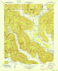
1950 Map of Eureka
USGS Topo · Published 1950About this map
The John Sumach Reservation and the sprawling Little Coon Mountain dominate this 1940s landscape on the border of Jackson County and Franklin County. This era captures the intricate relationship between the highland gaps, such as Looney Gap and Daniel Gap, and the valley floor where commerce centered around local gathering points like Brisco Store and Bell Store. The winding path of the Nashville Chattanooga and St Louis railway tracks the water of Crow Creek as it flows toward the edge of the Guntersville Reservoir. Numerous family-named burial grounds, including Round Cove Cem and Jacoway Cem, are scattered through the coves and hollows, providing a dense record of early settlement and genealogy in the Little Coon Valley.
Find a feature on this map
56 named features on this map. Tap any name to fly to it.
Don’t see what you’re looking for? This feature index may not catch every label — zoom into the map to look around manually.
Map Details
Editions of this 1950 Eureka Map
This is the sole edition of this map. No revisions or reprints were ever made.
Other maps of this area

1886 · Stevenson
USGS Topo · 1:125,000

1888 · Scottsboro
USGS Topo · 1:125,000

1892 · Scottsboro
USGS Topo · 1:125,000

1892 · Stevenson
USGS Topo · 1:125,000

1895 · Stevenson
USGS Topo · 1:125,000

1895 · Sewanee
USGS Topo · 1:125,000

1928 · Decherd
USGS Topo · 1:62,500

1936 · Orme
USGS Topo · 1:24,000

1936 · Wannville
USGS Topo · 1:24,000

1936 · Sinking Cove
USGS Topo · 1:24,000