
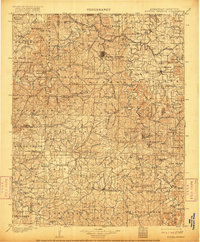
1901 Map of Eureka Springs
USGS Topo · Published 1949About this map
Eureka Springs serves as the focal point of this Ozark landscape, characterized by a complex network of river valleys and sharp ridges at the turn of the century. The map reveals a frontier economy transitioning into a regional hub, where the St. Louis and San Francisco RR skirts the western edge near Garfield. Before modern bridges dominated the terrain, river travel and crossing points were vital for local commerce, evidenced by Knox Ferry and Jennings Ford along the White River.
Find a feature on this map
106 named features on this map. Tap any name to fly to it.
Don’t see what you’re looking for? This feature index may not catch every label — zoom into the map to look around manually.
Map Details
Editions of this 1901 Eureka Springs Map
3 editions found
Other maps of this area

1898 · Winslow
USGS Topo · 1:125,000

1899 · Fayetteville
USGS Topo · 1:125,000

1900 · Eureka Springs
USGS Topo · 1:125,000

1901 · Winslow
USGS Topo · 1:125,000

1901 · Eureka Springs
USGS Topo · 1:125,000

1901 · Fayetteville
USGS Topo · 1:125,000

1904 · Fayetteville
USGS Topo · 1:125,000

1904 · Harrison
USGS Topo · 1:125,000

1905 · Harrison
USGS Topo · 1:125,000

1907 · Forsyth
USGS Topo · 1:125,000