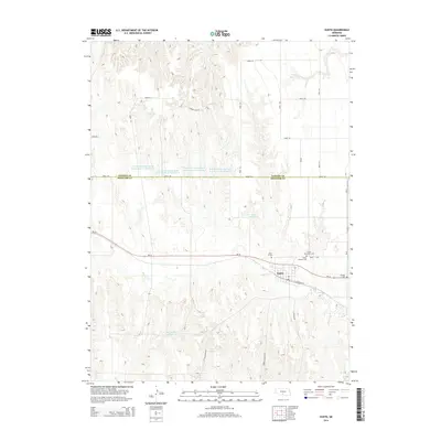
2014 Map of Eustis
USGS Topo · Published 2014About this map
Eustis serves as the primary hub of this Nebraska landscape, situated near the intersection of the Dawson Co and Frontier Co line. The town's local history is anchored by several sites of genealogical interest, including the Eustis Methodist Cem, Eustis Lutheran Cem, and the historic Pioneer Cem located to the east. The surrounding terrain is defined by an intricate network of drainage and water management, featuring numerous named catchments such as Yeutter Reservoir, Koch Reservoir, and Huettle Reservoir. These reservoirs, along with the meandering paths of Plum Cr and Muddy Cr, illustrate a rural economy heavily reliant on structured irrigation and water storage. The regular grid of county roads, including Road 750 and Ne-23, connects the dispersed agricultural parcels to the central settlement and its rail-aligned corridors like E Railroad St.
Find a feature on this map
26 named features on this map. Tap any name to fly to it.
Don’t see what you’re looking for? This feature index may not catch every label — zoom into the map to look around manually.
Map Details
Editions of this 2014 Eustis Map
This is the sole edition of this map. No revisions or reprints were ever made.
Other maps of this area

1896 · Lexington
USGS Topo · 1:125,000

1899 · Lexington
USGS Topo · 1:125,000

1902 · Gothenburg
USGS Topo · 1:125,000

1954 · McCook
USGS Topo · 1:250,000

1955 · Grand Island
USGS Topo · 1:250,000

1957 · McCook
USGS Topo · 1:250,000

1957 · Grand Island
USGS Topo · 1:250,000

1958 · McCook
USGS Topo · 1:250,000

1958 · Grand Island
USGS Topo · 1:250,000
1970 · Eustis SW
USGS Topo · 1:24,000