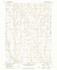
1970 Map of Eustis SW
USGS Topo · Published 1973About this map
West Muddy Creek and Deer Creek cut through this portion of Frontier County, defining a landscape of canyons and uplands mapped during the development of the Missouri River Basin. The township-and-range grid organizes the territory into named districts including Russell, Plum Creek, Horrell, and Logan, reflecting the rural organization of Nebraska's prairie land in the early 1970s.
Find a feature on this map
15 named features on this map. Tap any name to fly to it.
Don’t see what you’re looking for? This feature index may not catch every label — zoom into the map to look around manually.
Map Details
Editions of this 1970 Eustis SW Map
This is the sole edition of this map. No revisions or reprints were ever made.
Other maps of this area

1902 · Gothenburg
USGS Topo · 1:125,000

1954 · McCook
USGS Topo · 1:250,000

1956 · Freedom
USGS Topo · 1:24,000

1956 · Stockville NE
USGS Topo · 1:24,000

1956 · Medicine Creek Dam
USGS Topo · 1:24,000

1956 · Stockville SE
USGS Topo · 1:24,000

1957 · McCook
USGS Topo · 1:250,000

1958 · McCook
USGS Topo · 1:250,000
1970 · Eustis
USGS Topo · 1:24,000
1970 · Cambridge NE
USGS Topo · 1:24,000