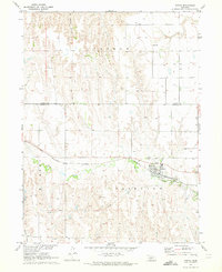
1970 Map of Eustis
USGS Topo · Published 1973About this map
Eustis serves as the focal point of this 1970s landscape, situated along the Burlington Northern railroad corridor on the border of Dawson and Frontier Counties. The map reveals a heavily dissected terrain dominated by watercourses like Plum Creek and Midway Canyon, which carve through the high plains. A notable industrial feature is the Silica Mine located south of town, indicating the local extraction of mineral resources during this era. Rural life is anchored by landmarks such as the Holmes Sch and the Eustis Cem, while smaller drainages like German Creek and Muddy Creek define the agricultural surrounding. The distribution of numerous wells across the townships of Farnam and Fairview underscores the region's reliance on groundwater for both domestic use and farming.
Find a feature on this map
17 named features on this map. Tap any name to fly to it.
Don’t see what you’re looking for? This feature index may not catch every label — zoom into the map to look around manually.
Map Details
Editions of this 1970 Eustis Map
This is the sole edition of this map. No revisions or reprints were ever made.
Other maps of this area

1896 · Lexington
USGS Topo · 1:125,000

1899 · Lexington
USGS Topo · 1:125,000

1902 · Gothenburg
USGS Topo · 1:125,000

1954 · McCook
USGS Topo · 1:250,000

1955 · Grand Island
USGS Topo · 1:250,000

1957 · McCook
USGS Topo · 1:250,000

1957 · Grand Island
USGS Topo · 1:250,000

1958 · McCook
USGS Topo · 1:250,000

1958 · Grand Island
USGS Topo · 1:250,000
1970 · Eustis SW
USGS Topo · 1:24,000