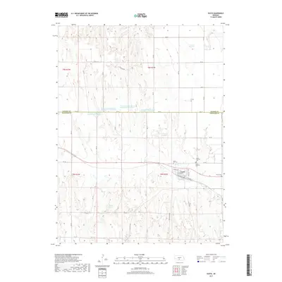
2017 Map of Eustis
USGS Topo · Published 2017About this map
Eustis anchors this landscape in the early 21st century, situated where the high plains of Frontier Co meet the southern edge of Dawson Co. The settlement is defined by a grid including Hendricks St, W Anthony St, and E Railroad St, reflecting its historical orientation to the rail line. This agricultural region is marked by an extensive water management system, featuring numerous irrigation and stock reservoirs such as Yeutter Reservoir, Hueftle Reservoir, and the series of numbered Dawson Company Road Dam Reservoirs. The drainage patterns of Plum Cr and Muddy Cr carve through the loess hills, creating a topography that dictates the placement of rural roads like Rd 750. Genealogists will find a cluster of community history at the Eustis Methodist Cem, Eustis Lutheran Cem, and the more remote Pioneer Cem to the east.
Find a feature on this map
34 named features on this map. Tap any name to fly to it.
Don’t see what you’re looking for? This feature index may not catch every label — zoom into the map to look around manually.
Map Details
Editions of this 2017 Eustis Map
This is the sole edition of this map. No revisions or reprints were ever made.
Other maps of this area

1896 · Lexington
USGS Topo · 1:125,000

1899 · Lexington
USGS Topo · 1:125,000

1902 · Gothenburg
USGS Topo · 1:125,000

1954 · McCook
USGS Topo · 1:250,000

1955 · Grand Island
USGS Topo · 1:250,000

1957 · McCook
USGS Topo · 1:250,000

1957 · Grand Island
USGS Topo · 1:250,000

1958 · McCook
USGS Topo · 1:250,000

1958 · Grand Island
USGS Topo · 1:250,000
1970 · Eustis SW
USGS Topo · 1:24,000