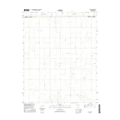
2016 Map of Eva NE
USGS Topo · Published 2016About this map
State Line Rd defines the northern boundary of this high plains region, marking the threshold where Morton Co, Kansas, meets Texas Co, Oklahoma. The landscape is characterized by a strict orthogonal grid of rural routes, including Road E, Rd 12, and Co Rd 11, which partition the territory into large agricultural blocks. This geometric layout is interrupted only by the meandering course of Cow Cr in the eastern half of the map, providing a rare natural break in the survey lines. For family historians, the presence of the Kuhn Cem near the eastern edge provides a localized point of interest within an otherwise expansive farming district. The reliance on numbered and lettered section roads like Co Rd 13 and Rd 15 reflects a landscape optimized for large-scale ranching and agriculture in the mid-2010s.
Find a feature on this map
38 named features on this map. Tap any name to fly to it.
Don’t see what you’re looking for? This feature index may not catch every label — zoom into the map to look around manually.
Map Details
Editions of this 2016 Eva NE Map
This is the sole edition of this map. No revisions or reprints were ever made.
Other maps of this area

1954 · Perryton
USGS Topo · 1:250,000

1955 · Dodge City
USGS Topo · 1:250,000

1958 · Perryton
USGS Topo · 1:250,000

1958 · Dodge City
USGS Topo · 1:250,000

1959 · Dodge City
USGS Topo · 1:250,000
1973 · Elkhart South
USGS Topo · 1:24,000

1973 · Eva SE
USGS Topo · 1:24,000
1973 · Elkhart North
USGS Topo · 1:24,000

1973 · Hough SW
USGS Topo · 1:24,000
1973 · Eva
USGS Topo · 1:24,000