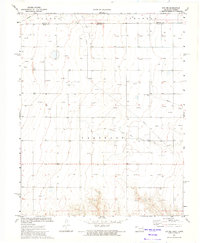
1973 Map of Eva NE
USGS Topo · Published 1975About this map
Carthage Oil and Gas Field dominates this High Plains landscape along the border of Kansas and Oklahoma, where the energy economy of the early 1970s is etched into the terrain. The map reveals an intensive network of extractive infrastructure, characterized by dozens of Gas Wells and Oil Wells connected by a complex system of pipelines. A large Gas Processing Plant serves as a central industrial hub for the local collection effort, illustrating the region's mid-century shift toward large-scale resource management. Amidst this modern industrial grid, traces of early settlement and rural life remain visible. The historic Kuhn Cem provides a genealogical touchstone, while Cow Creek provides the primary drainage for the townships of Taloga and Cimarron. The survey also marks the intersection of Morton and Texas counties, capturing a period when industrial development was fully integrated into the expansive agricultural sections of the Panhandle.
Find a feature on this map
12 named features on this map. Tap any name to fly to it.
Don’t see what you’re looking for? This feature index may not catch every label — zoom into the map to look around manually.
Map Details
Editions of this 1973 Eva NE Map
This is the sole edition of this map. No revisions or reprints were ever made.
Other maps of this area

1954 · Perryton
USGS Topo · 1:250,000

1955 · Dodge City
USGS Topo · 1:250,000

1958 · Perryton
USGS Topo · 1:250,000

1958 · Dodge City
USGS Topo · 1:250,000

1959 · Dodge City
USGS Topo · 1:250,000
1973 · Elkhart South
USGS Topo · 1:24,000

1973 · Eva SE
USGS Topo · 1:24,000
1973 · Elkhart North
USGS Topo · 1:24,000

1973 · Hough SW
USGS Topo · 1:24,000
1973 · Eva
USGS Topo · 1:24,000