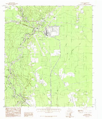
1984 Map of Evadale
USGS Topo · Published 1985About this map
The Big Thicket National Preserve dominates this landscape along the border of Hardin Co and Jasper Co, where the wandering course of the Big Neches River creates a complex system of oxbows and backwaters. The settlement of Evadale serves as a primary hub, situated near the industrial activity of the local mills and the crossing of Mill Creek. The map documents a transition in transportation, showing both an Abnd RR and an Old RR Grade that once carried the region's timber and freight.
Find a feature on this map
40 named features on this map. Tap any name to fly to it.
Don’t see what you’re looking for? This feature index may not catch every label — zoom into the map to look around manually.
Map Details
Editions of this 1984 Evadale Map
This is the sole edition of this map. No revisions or reprints were ever made.
Other maps of this area

1926 · Lakeview
USGS Topo · 1:24,000

1926 · Texla
USGS Topo · 1:24,000

1932 · Beaumont
USGS Topo · 1:62,500

1943 · Texla
USGS Topo · 1:24,000

1952 · Lake Charles
USGS Topo · 1:250,000

1954 · Lake Charles
USGS Topo · 1:250,000

1954 · Beaumont
USGS Topo · 1:250,000

1955 · Silsbee
USGS Topo · 1:62,500

1955 · Bessmay
USGS Topo · 1:62,500

1957 · Beaumont
USGS Topo · 1:250,000