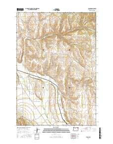
2017 Map of Evans
USGS Topo · Published 2017About this map
The Wallowa River and Lostine River converge in the southern reaches of this landscape, marking a significant hydrological junction in Wallowa County. The settlement of Evans sits near the base of the hills, while the Lostine Cem provides a focal point for genealogical interest on the valley floor. The terrain is defined by a dense network of drainages and creeks, including the complex branches of Whisky Cr to the north and the winding Parsnip Cr to the east.
Find a feature on this map
31 named features on this map. Tap any name to fly to it.
Don’t see what you’re looking for? This feature index may not catch every label — zoom into the map to look around manually.
Map Details
Editions of this 2017 Evans Map
This is the sole edition of this map. No revisions or reprints were ever made.
Other maps of this area

1906 · Telocaset
USGS Topo · 1:125,000

1955 · Grangeville
USGS Topo · 1:250,000

1957 · Enterprise
USGS Topo · 1:62,500

1957 · Sled Springs
USGS Topo · 1:62,500

1959 · Grangeville
USGS Topo · 1:250,000

1964 · Akers Butte
USGS Topo · 1:24,000

1964 · Wallowa
USGS Topo · 1:24,000

1965 · Fox Point
USGS Topo · 1:24,000

1982 · Wallowa
USGS Topo · 1:100,000
1984 · Akers Butte
USGS Topo · 1:24,000