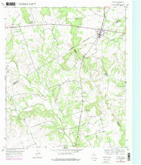
1954 Map of Evant
USGS Topo · Published 1979About this map
Evant serves as the central hub on this Central Texas landscape where three counties meet at a single point. Located at the intersection of the American Legion Memorial Highway and major regional routes, the town is characterized by its Athletic Field and proximity to local resources like the Evant Pumping Station. The surrounding countryside is defined by the winding course of the Lampasas River and Bennett Creek, punctuated by springs such as Beef Pen Spring and Brooks Spring. This mapping effort reveals a deeply rooted rural community, marked by numerous family and community burial grounds including Pilgrims Rest Cemetery, Murphy Cem, and Hines Chapel Cemetery. To the south, Faubion Crossing indicates a historic ford over the river, while the presence of Gholson Gap and a large Pipe Line corridor illustrates how both natural topography and modern infrastructure have shaped the movement of people and resources through this tri-county borderland.
Find a feature on this map
33 named features on this map. Tap any name to fly to it.
Don’t see what you’re looking for? This feature index may not catch every label — zoom into the map to look around manually.
Map Details
Editions of this 1954 Evant Map
2 editions found
Other maps of this area

1887 · Lampasas
USGS Topo · 1:125,000

1888 · Hamilton
USGS Topo · 1:125,000

1894 · Hamilton
USGS Topo · 1:125,000

1894 · Lampasas
USGS Topo · 1:125,000

1954 · Brownwood
USGS Topo · 1:250,000

1954 · Evant
USGS Topo · 1:62,500

1954 · Evant
USGS Topo · 1:24,000
1954 · Izoro
USGS Topo · 1:24,000
1954 · Pearl
USGS Topo · 1:24,000
1954 · Adamsville
USGS Topo · 1:24,000