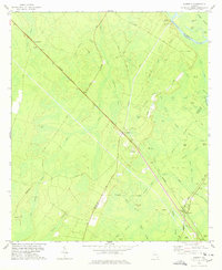
1978 Map of Everett
USGS Topo · Published 1978About this map
The Altamaha River defines the northeastern boundary of this coastal plain landscape, where dense river swamps meet a developed rail network. At the southern end of the sheet, the junction of the Southern and Seaboard Coast Line railroads anchors the community of Everett. The area's history is written in its small settlements and family landmarks, from Grangerville and Granger in the northwest to Mt Pleasant along the rail line.
Find a feature on this map
68 named features on this map. Tap any name to fly to it.
Don’t see what you’re looking for? This feature index may not catch every label — zoom into the map to look around manually.
Map Details
Editions of this 1978 Everett Map
This is the sole edition of this map. No revisions or reprints were ever made.
Other maps of this area

1918 · Jesup
USGS Topo · 1:62,500

1918 · Hortense
USGS Topo · 1:62,500

1918 · Everett City
USGS Topo · 1:62,500

1920 · Everett City
USGS Topo · 1:62,500

1943 · Ludowici
USGS Topo · 1:62,500

1943 · Jesup
USGS Topo · 1:62,500

1944 · Everett City
USGS Topo · 1:62,500

1944 · Hortense
USGS Topo · 1:62,500

1946 · Brunswick
USGS Topo · 1:250,000

1948 · Brunswick
USGS Topo · 1:250,000