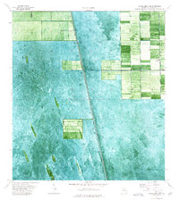
1974 Map of Everglades 2 NE
USGS Topo · Published 1976About this map
Miami Canal serves as the central drainage artery for this section of the Everglades, illustrating the mid-1970s push to manage the South Florida landscape for agricultural use. The orthophotomap format reveals a distinct pattern of land reclamation, where rectangular blocks of dark green vegetation contrast sharply against the lighter, undeveloped sawgrass marshes. The settlement of Talisman stands as a small pocket of activity within this highly engineered environment, supported by water control infrastructure such as Levee 23, a Gaging Station, and a Pump station. This map captures a specific phase of Palm Beach County history, documenting the transition of the wetlands into structured, productive plots through a system of canals and levees.
Find a feature on this map
6 named features on this map. Tap any name to fly to it.
Don’t see what you’re looking for? This feature index may not catch every label — zoom into the map to look around manually.
Map Details
Editions of this 1974 Everglades 2 NE Map
2 editions found
Other maps of this area

1956 · West Palm Beach
USGS Topo · 1:250,000

1957 · West Palm Beach
USGS Topo · 1:250,000

1958 · West Palm Beach
USGS Topo · 1:250,000

1970 · Lake Harbor SE
USGS Topo · 1:24,000

1970 · Lake Harbor SW
USGS Topo · 1:24,000

1970 · Okeelanta
USGS Topo · 1:24,000

1974 · Everglades 1 SW
USGS Topo · 1:24,000

1974 · Everglades 2 SW
USGS Topo · 1:24,000

1974 · Everglades 2 SE
USGS Topo · 1:24,000

1974 · Everglades 1 NW
USGS Topo · 1:24,000