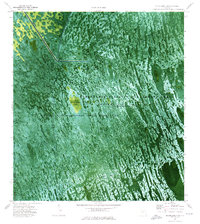
1974 Map of Everglades 3 SE
USGS Topo · Published 1976About this map
The Florida State Miccosukee Indian Reservation dominates this 1970s orthophotomap, showing the intricate sawgrass and water patterns of the central Everglades. Unlike traditional topographic sheets, this aerial-based survey uses color-infrared photography to reveal the subtle texture of the landscape, where tree islands like Horseshoe Head rise above the seasonally flooded marshes of Conservation Area No 3A.
Find a feature on this map
18 named features on this map. Tap any name to fly to it.
Don’t see what you’re looking for? This feature index may not catch every label — zoom into the map to look around manually.
Map Details
Editions of this 1974 Everglades 3 SE Map
2 editions found
Other maps of this area

1956 · Miami
USGS Topo · 1:250,000

1956 · West Palm Beach
USGS Topo · 1:250,000

1957 · West Palm Beach
USGS Topo · 1:250,000

1958 · West Palm Beach
USGS Topo · 1:250,000

1958 · Miami
USGS Topo · 1:250,000

1973 · Custard Apple Hammock
USGS Topo · 1:24,000

1973 · Everglades 4 NW
USGS Topo · 1:24,000

1973 · North Of Fiftymile Bend
USGS Topo · 1:24,000
1973 · Everglades 4 SW
USGS Topo · 1:24,000

1973 · Everglades 3 NE
USGS Topo · 1:24,000