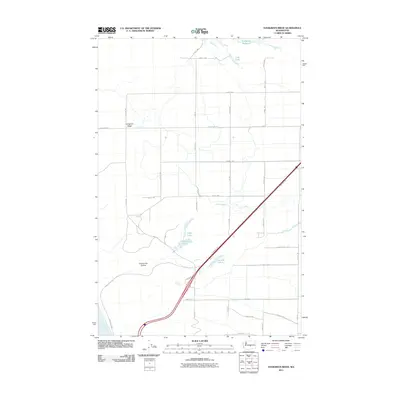
2011 Map of Evergreen Ridge
USGS Topo · Published 2011About this map
Evergreen Ridge dominates this Grant County landscape, providing a high vantage point overlooking the significant geological depression of Frenchman Coulee. The terrain is characterized by a high-desert irrigation and drainage network, featuring bodies of water such as Evergreen Reservoir and Cree Lake to the north, which transition into the more isolated Hillton Lake and Caliche Lakes further south. The Columbia River forms a critical boundary at the southwestern corner, near where Vantage St SW descends toward the water. This 2011 survey illustrates the grid-based rural road system typical of Washington's central basin, with major routes like Silica Rd and N Frontage Rd bisecting the arid stretches between the coulee and the reservoir.
Find a feature on this map
36 named features on this map. Tap any name to fly to it.
Don’t see what you’re looking for? This feature index may not catch every label — zoom into the map to look around manually.
Map Details
Editions of this 2011 Evergreen Ridge Map
This is the sole edition of this map. No revisions or reprints were ever made.
Other maps of this area

1909 · Quincy
USGS Topo · 1:62,500

1910 · Quincy
USGS Topo · 1:62,500

1912 · Beverly
USGS Topo · 1:62,500

1920 · Colockum Pass
USGS Topo · 1:125,000

1922 · Colockum Pass
USGS Topo · 1:125,000

1939 · Boylston
USGS Topo · 1:48,000

1943 · Boylston
USGS Topo · 1:62,500

1950 · Yakima
USGS Topo · 1:250,000

1953 · Ginkgo
USGS Topo · 1:24,000
1953 · Boylston
USGS Topo · 1:62,500