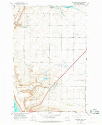
1966 Map of Evergreen Ridge
USGS Topo · Published 1968About this map
Evergreen Ridge and the broad basalt plateaus of Grant County dominate this mid-century survey of Central Washington's arid interior. The landscape is defined by the massive engineering projects of the Columbia Basin Project, characterized by an extensive irrigation network including the Aqueduct, a large Siphon, and the Evergreen Pumping Plant. These features facilitated the movement of water from the Columbia River to the agricultural lands above the coulees.
Find a feature on this map
24 named features on this map. Tap any name to fly to it.
Don’t see what you’re looking for? This feature index may not catch every label — zoom into the map to look around manually.
Map Details
Editions of this 1966 Evergreen Ridge Map
This is the sole edition of this map. No revisions or reprints were ever made.
Other maps of this area

1909 · Quincy
USGS Topo · 1:62,500

1910 · Quincy
USGS Topo · 1:62,500

1912 · Beverly
USGS Topo · 1:62,500

1920 · Colockum Pass
USGS Topo · 1:125,000

1922 · Colockum Pass
USGS Topo · 1:125,000

1939 · Boylston
USGS Topo · 1:48,000

1943 · Boylston
USGS Topo · 1:62,500

1950 · Yakima
USGS Topo · 1:250,000

1953 · Ginkgo
USGS Topo · 1:24,000
1953 · Boylston
USGS Topo · 1:62,500