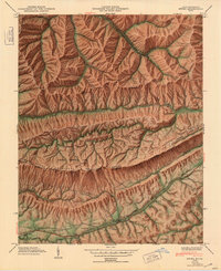
1949 Map of Ewing
USGS Topo · Published 1953About this map
Cumberland Mountain dominates the center of this 1946 field examination, where the ridge lines define the border between Kentucky and Virginia. To the south, the valley floor around Ewing and Caylor is dotted with family cemeteries and small rural schools like Walker Sch and Evergreen Sch, reflecting a deeply established mountain community. The Louisville and Nashville railroad runs parallel to the Boone Trail, tracing the historical migration route through the gap. The northern portion of the map reveals the industrial character of the era, marked by several inclines serving mines along the steep slopes of Black Mountain and the settlement of Alva. This survey captures the transition from the agricultural valley, where Cowan Mill and Kesterson Mill stood, to the extractive economies and early preservation efforts at Cumberland National Historical Park.
Find a feature on this map
79 named features on this map. Tap any name to fly to it.
Don’t see what you’re looking for? This feature index may not catch every label — zoom into the map to look around manually.
Map Details
Editions of this 1949 Ewing Map
2 editions found
Other maps of this area

1886 · Cumberland Gap
USGS Topo · 1:125,000

1887 · Jonesville
USGS Topo · 1:125,000

1888 · Cumberland Gap
USGS Topo · 1:125,000

1891 · Cumberland Gap
USGS Topo · 1:125,000

1891 · Jonesville
USGS Topo · 1:125,000

1903 · Harlan
USGS Topo · 1:48,000

1903 · Pineville
USGS Topo · 1:48,000

1903 · Middlesboro
USGS Topo · 1:48,000

1916 · Harlan
USGS Topo · 1:48,000

1919 · Harlan
USGS Topo · 1:62,500