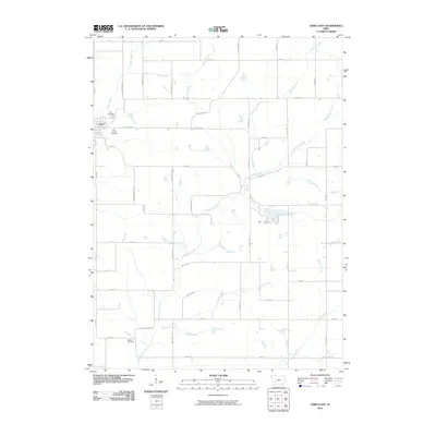
2010 Map of Exira East
USGS Topo · Published 2010About this map
Exira sits at the western edge of this agricultural landscape in Audubon County, where the town's early footprint is anchored by the Exira Cemetery and Holy Trinity Cemetery. The surrounding countryside is defined by a dendritic network of waterways, most notably Troublesome Creek and Pleasant Creek, which carve through the Iowa prairie. This 2010 survey shows the section-line road system that organizes the region, including named routes like Lark Ave and Littlefield Dr that connect dispersed farmsteads. To the south, the Bowen Cemetery serves as a lone landmark in the open fields near the winding path of Crooked Creek. This map illustrates the intersection of small-town Iowa life and the vast drainage patterns of the Missouri River watershed, capturing a moment when family-held lands and rural cemeteries remain the primary markers of the local heritage.
Find a feature on this map
36 named features on this map. Tap any name to fly to it.
Don’t see what you’re looking for? This feature index may not catch every label — zoom into the map to look around manually.
Map Details
Editions of this 2010 Exira East Map
This is the sole edition of this map. No revisions or reprints were ever made.
Other maps of this area

1954 · Omaha
USGS Topo · 1:250,000

1957 · Omaha
USGS Topo · 1:250,000

1957 · Audubon
USGS Topo · 1:62,500

1958 · Omaha
USGS Topo · 1:250,000

1971 · Adair South
USGS Topo · 1:24,000

1971 · Anita
USGS Topo · 1:24,000

1971 · Wiota
USGS Topo · 1:24,000

1971 · North Branch
USGS Topo · 1:24,000
1971 · Adair North
USGS Topo · 1:24,000
1983 · Exira West
USGS Topo · 1:24,000