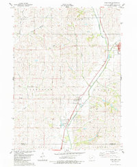
1983 Map of Exira West
USGS Topo · Published 1984About this map
The East Nishnabotna River corridor defines the eastern edge of this agricultural landscape in Audubon County. The town of Exira sits along the river's eastern bank, marked by its local Po and High Sch, while the smaller settlement of Brayton is positioned further south where the river bends. This early 1980s record illustrates a rural economy rooted in both the land and extraction, featuring a Quarry near Oakfield Cem and a Sandpit located near the southern boundary line between Audubon Co Cass Co. Genealogists will find several burial grounds across the townships of Sharon, Hamlin, and Oakfield, including St Johns Cem and Oak Hill Cem. The terrain is characterized by the branching drainages of Elkhorn Creek and Sifford Creek, which carve through the Iowa prairie upland.
Find a feature on this map
35 named features on this map. Tap any name to fly to it.
Don’t see what you’re looking for? This feature index may not catch every label — zoom into the map to look around manually.
Map Details
Editions of this 1983 Exira West Map
This is the sole edition of this map. No revisions or reprints were ever made.
Other maps of this area

1954 · Omaha
USGS Topo · 1:250,000

1957 · Omaha
USGS Topo · 1:250,000

1957 · Audubon
USGS Topo · 1:62,500

1958 · Omaha
USGS Topo · 1:250,000

1971 · Anita
USGS Topo · 1:24,000

1971 · Wiota
USGS Topo · 1:24,000

1971 · Atlantic
USGS Topo · 1:24,000

1978 · Elk Horn
USGS Topo · 1:24,000

1978 · Kimballton
USGS Topo · 1:24,000
1980 · Harlan
USGS Topo · 1:100,000