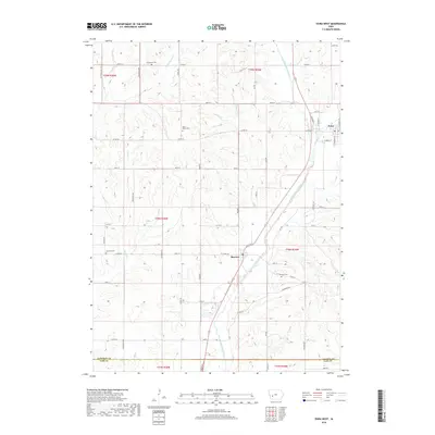
2018 Map of Exira West
USGS Topo · Published 2018About this map
The East Nishnabotna River carves a central valley through this section of Audubon County, creating a distinct landscape where local agriculture and small-town life converge. The settlement of Brayton sits along the river's western bank, while Exira occupies the northeastern edge of the sheet, where Railroad St and Davids Cr meet. This 2018 survey reveals a well-established network of rural cemeteries, including Oak Hill Cem, Saint Johns Cem, and the Adventist Cem to the north, which serve as vital touchstones for family history researchers in the region. Tributaries like Little Indian Cr, Elkhorn Cr, and Sifford Cr branch out into the surrounding hills, defining the drainage patterns of the fertile Iowa plains. The map also records the boundary between Audubon County and Cass County at its southern margin, illustrating the geopolitical layout of these agricultural townships.
Find a feature on this map
48 named features on this map. Tap any name to fly to it.
Don’t see what you’re looking for? This feature index may not catch every label — zoom into the map to look around manually.
Map Details
Editions of this 2018 Exira West Map
This is the sole edition of this map. No revisions or reprints were ever made.
Other maps of this area

1954 · Omaha
USGS Topo · 1:250,000

1957 · Omaha
USGS Topo · 1:250,000

1957 · Audubon
USGS Topo · 1:62,500

1958 · Omaha
USGS Topo · 1:250,000

1971 · Anita
USGS Topo · 1:24,000

1971 · Wiota
USGS Topo · 1:24,000

1971 · Atlantic
USGS Topo · 1:24,000

1978 · Elk Horn
USGS Topo · 1:24,000

1978 · Kimballton
USGS Topo · 1:24,000
1980 · Harlan
USGS Topo · 1:100,000