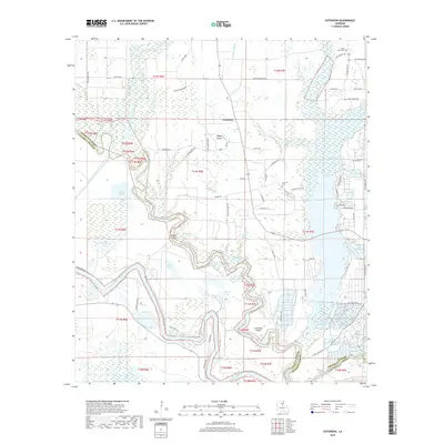
2018 Map of Extension
USGS Topo · Published 2018About this map
Boeuf River and the Ouachita River wind through the bottomlands of Franklin and Catahoula Parishes, creating a landscape defined by oxbows, brakes, and ridges. The settlement of Extension serves as a central point in this alluvial plain, surrounded by the open grounds of Boeuf Prairie. The map captures a complex network of bayous including Grayson Bayou, Flowers Bayou, and Cutoff Bayou, which thread through the low-lying terrain alongside landmarks like Rabbit Island and Cocklebur Island. Local history is preserved in the location of several family and community burial grounds, such as Shady Grove Cem, Carrway Cem, and King Cem. Transport throughout the river basin is marked by specialized routes like Duty Ferry Rd and McGuffee Bend Rd, reflecting the historical reliance on river crossings and the specific contours of the delta landscape.
Find a feature on this map
74 named features on this map. Tap any name to fly to it.
Don’t see what you’re looking for? This feature index may not catch every label — zoom into the map to look around manually.
Map Details
Editions of this 2018 Extension Map
This is the sole edition of this map. No revisions or reprints were ever made.
Other maps of this area

1935 · Winnsboro
USGS Topo · 1:62,500

1939 · Fort Necessity
USGS Topo · 1:62,500

1941 · Sicily Island
USGS Topo · 1:62,500

1941 · Harrisonburg
USGS Topo · 1:62,500

1953 · Natchez
USGS Topo · 1:250,000

1955 · Jackson
USGS Topo · 1:250,000

1956 · Natchez
USGS Topo · 1:250,000

1957 · Sicily Island
USGS Topo · 1:62,500

1958 · Winnsboro
USGS Topo · 1:62,500

1958 · Fort Necessity
USGS Topo · 1:62,500