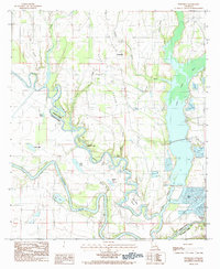
1984 Map of Extension
USGS Topo · Published 1985About this map
Extension sits at the heart of this landscape, positioned between the winding courses of the Boeuf River and the Quachita River in the early 1980s. The area is defined by its complex hydrology, where an intricate network of waterways like Grayson Bayou and Duck Creek feed into numerous oxbow lakes and basins. The topography reveals the natural drainage patterns of the Prairie, showing how the land transitions from the elevated banks near Extension toward the low-lying wetlands of Turkey Creek Lake on the eastern edge.
Find a feature on this map
30 named features on this map. Tap any name to fly to it.
Don’t see what you’re looking for? This feature index may not catch every label — zoom into the map to look around manually.
Map Details
Editions of this 1984 Extension Map
This is the sole edition of this map. No revisions or reprints were ever made.
Other maps of this area

1935 · Winnsboro
USGS Topo · 1:62,500

1939 · Fort Necessity
USGS Topo · 1:62,500

1941 · Sicily Island
USGS Topo · 1:62,500

1941 · Harrisonburg
USGS Topo · 1:62,500

1953 · Natchez
USGS Topo · 1:250,000

1955 · Jackson
USGS Topo · 1:250,000

1956 · Natchez
USGS Topo · 1:250,000

1957 · Sicily Island
USGS Topo · 1:62,500

1958 · Winnsboro
USGS Topo · 1:62,500

1958 · Fort Necessity
USGS Topo · 1:62,500