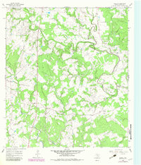
1964 Map of Ezzell
USGS Topo · Published 1983About this map
The Lavaca River meanders through this landscape of rural Lavaca County, defining the character of the terrain at Tiger Bend. In the mid-1960s, the area was characterized by small agricultural clusters and a network of creeks like Mustang Creek and Rocky Creek that fed into the main river channel. The settlement of Ezzell and the community at Koerth served as local hubs, connected by winding unimproved roads and State Route 77.
Find a feature on this map
22 named features on this map. Tap any name to fly to it.
Don’t see what you’re looking for? This feature index may not catch every label — zoom into the map to look around manually.
Map Details
Editions of this 1964 Ezzell Map
2 editions found
Other maps of this area

1953 · Seguin
USGS Topo · 1:250,000

1958 · Seguin
USGS Topo · 1:250,000

1962 · Terryville
USGS Topo · 1:24,000

1962 · Sublime
USGS Topo · 1:24,000

1962 · Hallettsville SE
USGS Topo · 1:24,000

1962 · Hallettsville
USGS Topo · 1:24,000

1963 · Sweet Home
USGS Topo · 1:24,000

1964 · Morales
USGS Topo · 1:24,000

1964 · Ezzell
USGS Topo · 1:24,000

1965 · Wied
USGS Topo · 1:24,000