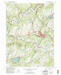
1994 Map of Factoryville
USGS Topo · Published 1996About this map
Tunkhannock Creek winds through the heart of the northeastern Pennsylvania countryside, anchoring a landscape where small educational centers and quiet settlements define the local character. In Factoryville, the campus of Keystone Junior College stands alongside the Roosevelt Highway, while the nearby St Pius Seminary and Lackawanna Trail High Sch highlight the region's commitment to community institutions. The terrain is marked by high points like Bunker Hill and Thomas Hill, which overlook narrow valleys and scattered water bodies.
Find a feature on this map
61 named features on this map. Tap any name to fly to it.
Don’t see what you’re looking for? This feature index may not catch every label — zoom into the map to look around manually.
Map Details
Editions of this 1994 Factoryville Map
This is the sole edition of this map. No revisions or reprints were ever made.
Other maps of this area

1889 · Scranton
USGS Topo · 1:62,500

1891 · Scranton
USGS Topo · 1:62,500

1892 · Dundaff
USGS Topo · 1:62,500

1893 · Pittston
USGS Topo · 1:62,500

1893 · Scranton
USGS Topo · 1:62,500

1943 · Scranton
USGS Topo · 1:125,000

1946 · Tunkhannock
USGS Topo · 1:62,500

1946 · Dalton
USGS Topo · 1:24,000

1946 · Ransom
USGS Topo · 1:24,000

1946 · Factoryville
USGS Topo · 1:24,000