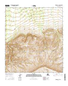
2016 Map of Fairbanks A-1 SE
USGS Topo · Published 2016About this map
Dry Cr descends through the rugged interior of the Alaska Range within the Alaska-Denali Borough as documented in this 2016 topographic study. The landscape is defined by its dramatic elevation changes, with contours rising from approximately 1,600 feet to over 4,000 feet in the southern sections. This area, largely devoid of permanent human infrastructure or settlements, is strictly organized by the Public Land Survey System, spanning township lines t9s r3e, t9s r4e, t10s r3e, and t10s r4e. The map serves as a primary record of the drainage patterns and high-altitude topography in this undeveloped corridor of the state, focusing on the natural contours and the intermittent flow of mountain streams.
Find a feature on this map
5 named features on this map. Tap any name to fly to it.
Don’t see what you’re looking for? This feature index may not catch every label — zoom into the map to look around manually.
Map Details
Editions of this 2016 Fairbanks A-1 SE Map
This is the sole edition of this map. No revisions or reprints were ever made.
Other maps of this area

1949 · Big Delta A-6
USGS Topo · 1:63,360

1949 · Fairbanks A-1
USGS Topo · 1:63,360

1949 · Healy D-1
USGS Topo · 1:63,360

1950 · Fairbanks
USGS Topo · 1:250,000

1950 · Mount Hayes
USGS Topo · 1:250,000

1950 · Big Delta
USGS Topo · 1:250,000

1950 · Mount Hayes D-6
USGS Topo · 1:63,360

1951 · Healy
USGS Topo · 1:250,000

1951 · Big Delta
USGS Topo · 1:250,000

1951 · Mount Hayes
USGS Topo · 1:250,000