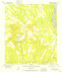
1951 Map of Fairbanks B-1
USGS Topo · Published 1951About this map
The Tanana River meanders along the eastern edge of this mid-century sub-arctic landscape, defining the limit of a significant Ladd Air Force Base Military Reservation Boundary. The interior is dominated by the Bombing and Gunnery Range, a massive tract of land used for Cold War-era training and operations south of Fairbanks. The terrain is characterized by the low-lying Blair Lakes and the seasonal flow of Dry Creek, set against the backdrop of the Tanana's braided channels. A remote airstrip near the lakes and the prominent VABM Flat 1406 point represent the sparse human footprint in this interior wilderness. The map captures the scale of military land use in Alaska during the early 1950s, showing how vast segments of the territory were dedicated to defense and aviation as the territory's strategic importance grew.
Find a feature on this map
11 named features on this map. Tap any name to fly to it.
Don’t see what you’re looking for? This feature index may not catch every label — zoom into the map to look around manually.
Map Details
Editions of this 1951 Fairbanks B-1 Map
2 editions found
Other maps of this area

1949 · Big Delta B-6
USGS Topo · 1:63,360

1949 · Fairbanks C-1
USGS Topo · 1:63,360

1949 · Big Delta C-6
USGS Topo · 1:63,360

1949 · Fairbanks C-2
USGS Topo · 1:63,360

1949 · Big Delta A-6
USGS Topo · 1:63,360

1949 · Fairbanks A-2
USGS Topo · 1:63,360

1949 · Fairbanks A-1
USGS Topo · 1:63,360

1950 · Fairbanks
USGS Topo · 1:250,000

1950 · Big Delta
USGS Topo · 1:250,000

1950 · Fairbanks C-1
USGS Topo · 1:63,360