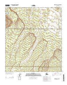
2013 Map of Fairbanks B-1 SE
USGS Topo · Published 2013About this map
Birch Lake sits near the northwestern corner of this interior Alaskan landscape, providing a rare landmark in a region defined by the winding course of McDonald Cr. This 2013 survey primarily documents the borderlands of the Fairbanks North Star Denali boundary, where the Tanana Valley gives way to the rising elevations of the interior foothills. The map reveals a largely undeveloped terrain, marked primarily by the administrative lines of the Public Land Survey System and the natural drainage patterns that flow toward the Tanana River system. The absence of modern infrastructure beyond basic road corridors underscores the remote character of this part of the Fairbanks North Star Borough during the early twenty-first century.
Find a feature on this map
8 named features on this map. Tap any name to fly to it.
Don’t see what you’re looking for? This feature index may not catch every label — zoom into the map to look around manually.
Map Details
Editions of this 2013 Fairbanks B-1 SE Map
This is the sole edition of this map. No revisions or reprints were ever made.
Other maps of this area

1949 · Big Delta B-6
USGS Topo · 1:63,360

1949 · Big Delta A-6
USGS Topo · 1:63,360

1949 · Fairbanks A-1
USGS Topo · 1:63,360

1950 · Fairbanks
USGS Topo · 1:250,000

1950 · Big Delta
USGS Topo · 1:250,000

1950 · Fairbanks B-1
USGS Topo · 1:63,360

1951 · Big Delta
USGS Topo · 1:250,000
1951 · Fairbanks B-1
USGS Topo · 1:63,360
1951 · Big Delta A-6
USGS Topo · 1:63,360

1951 · Fairbanks
USGS Topo · 1:250,000