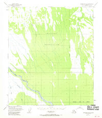
1950 Map of Fairbanks B-2
USGS Topo · Published 1970About this map
The Wood River meanders through the lower portion of this 1950 survey, defining the southern boundary of a significant Military Reservation. This terrain within the Fairbanks North Star Borough is characterized by its complex hydrology, where numerous waterways like Willow Creek and Clear Creek flow northward across the reservation.
Find a feature on this map
10 named features on this map. Tap any name to fly to it.
Don’t see what you’re looking for? This feature index may not catch every label — zoom into the map to look around manually.
Map Details
Editions of this 1950 Fairbanks B-2 Map
4 editions found
Other maps of this area

1949 · Fairbanks C-1
USGS Topo · 1:63,360

1949 · Fairbanks C-2
USGS Topo · 1:63,360

1949 · Fairbanks B-3
USGS Topo · 1:63,360

1949 · Fairbanks A-2
USGS Topo · 1:63,360

1949 · Fairbanks A-1
USGS Topo · 1:63,360

1950 · Fairbanks
USGS Topo · 1:250,000

1950 · Fairbanks C-3
USGS Topo · 1:63,360

1950 · Fairbanks A-3
USGS Topo · 1:63,360

1950 · Fairbanks C-1
USGS Topo · 1:63,360

1950 · Fairbanks B-2
USGS Topo · 1:63,360