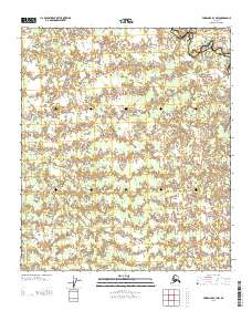
2013 Map of Fairbanks B-3 NW
USGS Topo · Published 2013About this map
Wood River winds through the northeast corner of this 2013 survey, which documents the interior Alaskan wilderness along the border of the Yukon-Koyukuk and Fairbanks North Star boroughs. The landscape is defined by a dense network of wetlands and small water bodies characteristic of the Tanana Valley permafrost region. In the western reaches of the quadrangle, Tatlanika Cr cuts through the lowlands. This survey by the U.S. Geological Survey provides a precise record of the shifting hydrography in a region where few permanent structures or roads exist. The map is primarily an ecological and topographical study, serving researchers tracking the changes in subarctic river systems and boundary surveyors identifying the precise limits between these two major administrative districts.
Find a feature on this map
3 named features on this map. Tap any name to fly to it.
Don’t see what you’re looking for? This feature index may not catch every label — zoom into the map to look around manually.
Map Details
Editions of this 2013 Fairbanks B-3 NW Map
This is the sole edition of this map. No revisions or reprints were ever made.
Other maps of this area

1949 · Fairbanks B-4
USGS Topo · 1:63,360

1949 · Fairbanks B-3
USGS Topo · 1:63,360

1950 · Fairbanks
USGS Topo · 1:250,000

1950 · Fairbanks C-3
USGS Topo · 1:63,360

1950 · Fairbanks C-4
USGS Topo · 1:63,360

1951 · Fairbanks
USGS Topo · 1:250,000

1952 · Fairbanks C-4
USGS Topo · 1:63,360
1952 · Fairbanks B-4
USGS Topo · 1:63,360
1952 · Fairbanks B-3
USGS Topo · 1:63,360
1952 · Fairbanks C-3
USGS Topo · 1:63,360