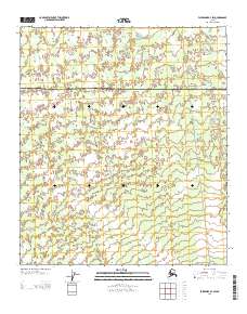
2013 Map of Fairbanks B-4 SW
USGS Topo · Published 2013About this map
The boundary between Yukon-Koyukuk and Denali divides this Alaskan landscape, where the braided channels of the Totatlanika River and Fish Cr define the drainage patterns of the interior. This 2013 survey documents a remote area characterized by limited infrastructure and immense open space, with the residential grouping at Clear Mews serving as a primary point of human settlement. Transportation through the region relies on established routes such as the Sled Rd, reflecting the traditional and seasonal methods of traversing this northern terrain. The map provides a precise view of the township and range system at the transition between the Yukon-Koyukuk and Denali boroughs, useful for understanding land management and boundary lines in the Alaskan wilderness during the early twenty-first century.
Find a feature on this map
8 named features on this map. Tap any name to fly to it.
Don’t see what you’re looking for? This feature index may not catch every label — zoom into the map to look around manually.
Map Details
Editions of this 2013 Fairbanks B-4 SW Map
This is the sole edition of this map. No revisions or reprints were ever made.
Other maps of this area

1949 · Fairbanks B-5
USGS Topo · 1:63,360

1949 · Fairbanks B-4
USGS Topo · 1:63,360

1950 · Fairbanks
USGS Topo · 1:250,000

1950 · Fairbanks A-5
USGS Topo · 1:63,360

1950 · Fairbanks A-4
USGS Topo · 1:63,360

1950 · Fairbanks B-5
USGS Topo · 1:63,360

1951 · Fairbanks B-5
USGS Topo · 1:63,360

1951 · Fairbanks
USGS Topo · 1:250,000

1951 · Fairbanks A-5
USGS Topo · 1:63,360
1952 · Fairbanks A-4
USGS Topo · 1:63,360