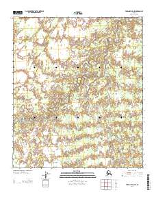
2013 Map of Fairbanks B-5 NW
USGS Topo · Published 2013About this map
The Nenana River and Teklanika River dominate this interior Alaska landscape within the Yukon-Koyukuk region. This 2013 survey illustrates the intricate braided watercourses and marshy lowlands typical of the area south of the Tanana River valley. A prominent Sled Rd cuts diagonally across the northern and central sections of the sheet, reflecting the historical and modern reliance on seasonal trail systems for travel across the subarctic terrain. The proximity of these major river systems, including the W Middle River, highlights a complex hydrological network where land and water shift seasonally. While the map is devoid of permanent settlements, the presence of these established river names and the winter transit route provides essential spatial data for navigating this stretch of the Alaskan interior.
Find a feature on this map
6 named features on this map. Tap any name to fly to it.
Don’t see what you’re looking for? This feature index may not catch every label — zoom into the map to look around manually.
Map Details
Editions of this 2013 Fairbanks B-5 NW Map
This is the sole edition of this map. No revisions or reprints were ever made.
Other maps of this area

1949 · Fairbanks B-5
USGS Topo · 1:63,360

1950 · Fairbanks
USGS Topo · 1:250,000

1950 · Fairbanks C-5
USGS Topo · 1:63,360

1950 · Fairbanks B-5
USGS Topo · 1:63,360

1951 · Fairbanks B-5
USGS Topo · 1:63,360

1951 · Fairbanks
USGS Topo · 1:250,000
1952 · Fairbanks C-5
USGS Topo · 1:63,360

1952 · Fairbanks
USGS Topo · 1:250,000
1953 · Fairbanks C-6
USGS Topo · 1:63,360
1953 · Fairbanks B-6
USGS Topo · 1:63,360