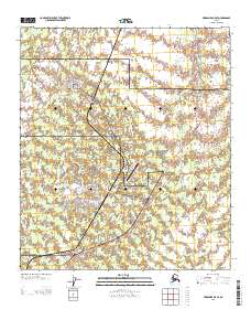
2013 Map of Fairbanks B-5 SE
USGS Topo · Published 2013About this map
Anderson sits at the northern end of this interior Alaskan landscape, serving as a primary settlement alongside the significant military presence at the Clear Air Force Sta. The region is defined by its transportation and defense infrastructure, with the Parks Hwy cutting through the eastern portion and the Anderson Rd connecting the town to the air station and the Clear Airport. This area marks the boundary between the Yukon-Koyukuk and Denali regions, where the human footprint is clustered around the Po and the residential area at Clear Mews. Waterways like Glacier Cr and Lost Slough weave through the terrain, illustrating the drainage patterns of the Tanana Valley. Further south, the Clear-Sky Lodge Airport provides additional aviation access near the highway, emphasizing the importance of air travel in this remote part of the state.
Find a feature on this map
15 named features on this map. Tap any name to fly to it.
Don’t see what you’re looking for? This feature index may not catch every label — zoom into the map to look around manually.
Map Details
Editions of this 2013 Fairbanks B-5 SE Map
This is the sole edition of this map. No revisions or reprints were ever made.
Other maps of this area

1949 · Fairbanks B-5
USGS Topo · 1:63,360

1949 · Fairbanks B-4
USGS Topo · 1:63,360

1950 · Fairbanks
USGS Topo · 1:250,000

1950 · Fairbanks A-5
USGS Topo · 1:63,360

1950 · Fairbanks A-4
USGS Topo · 1:63,360

1950 · Fairbanks B-5
USGS Topo · 1:63,360

1951 · Fairbanks B-5
USGS Topo · 1:63,360

1951 · Fairbanks
USGS Topo · 1:250,000

1951 · Fairbanks A-5
USGS Topo · 1:63,360
1952 · Fairbanks A-4
USGS Topo · 1:63,360