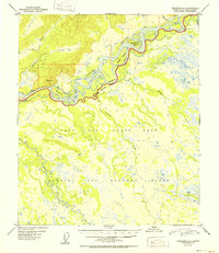
1952 Map of Fairbanks C-3
USGS Topo · Published 1952About this map
The Tanana River dominates this mid-century landscape south of Fairbanks, acting as a braided artery through a region defined by its cold-war military presence. The terrain south of the river is largely occupied by the Ladd Air Force Base, with a significant portion dedicated to a Bombing and Gunnery Range. This 1952 edition reflects an era when the Alaskan interior was being heavily mapped for strategic defense, revealing a landscape of winding waterways like the Wood River and complex slough systems including Sevenmile Slough and Hot Slough. The intricate network of islands, such as Whiskey Island and Sam Charley Island, illustrates the shifting, seasonal nature of the Tanana's floodplains before extensive modern channelization or development altered the flow patterns of these northern silty waters.
Find a feature on this map
23 named features on this map. Tap any name to fly to it.
Don’t see what you’re looking for? This feature index may not catch every label — zoom into the map to look around manually.
Map Details
Editions of this 1952 Fairbanks C-3 Map
2 editions found
Other maps of this area

1949 · Fairbanks D-2
USGS Topo · 1:62,500

1949 · Fairbanks D-3
USGS Topo · 1:63,360

1949 · Fairbanks D-4
USGS Topo · 1:63,360

1949 · Fairbanks C-2
USGS Topo · 1:63,360

1949 · Fairbanks B-4
USGS Topo · 1:63,360

1949 · Fairbanks B-3
USGS Topo · 1:63,360

1950 · Fairbanks
USGS Topo · 1:250,000

1950 · Fairbanks C-3
USGS Topo · 1:63,360

1950 · Fairbanks C-4
USGS Topo · 1:63,360

1950 · Fairbanks B-2
USGS Topo · 1:63,360