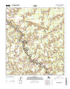
2013 Map of Fairbanks C-3 SW
USGS Topo · Published 2013About this map
Wood River serves as the central physical artery for this interior Alaskan landscape, its winding course carving through a complex network of wetlands and oxbow lakes. The map records the jurisdictional divide of the Fairbanks North Star and Yukon-Koyukuk boundary, which follows the meandering path of the river through this unpopulated expanse. This 2013 survey illustrates a wilderness defined by its hydrography, where the shifting river channel creates a mosaic of seasonal water bodies and marshes. The lack of road infrastructure or permanent settlements underscores the region's character as a remote corridor between the Tanana Valley and the Alaska Range foothills, where natural drainage patterns dictate the structure of the land.
Find a feature on this map
2 named features on this map. Tap any name to fly to it.
Don’t see what you’re looking for? This feature index may not catch every label — zoom into the map to look around manually.
Map Details
Editions of this 2013 Fairbanks C-3 SW Map
This is the sole edition of this map. No revisions or reprints were ever made.
Other maps of this area

1949 · Fairbanks B-4
USGS Topo · 1:63,360

1949 · Fairbanks B-3
USGS Topo · 1:63,360

1950 · Fairbanks
USGS Topo · 1:250,000

1950 · Fairbanks C-3
USGS Topo · 1:63,360

1950 · Fairbanks C-4
USGS Topo · 1:63,360

1951 · Fairbanks
USGS Topo · 1:250,000

1952 · Fairbanks C-4
USGS Topo · 1:63,360
1952 · Fairbanks B-4
USGS Topo · 1:63,360
1952 · Fairbanks B-3
USGS Topo · 1:63,360
1952 · Fairbanks C-3
USGS Topo · 1:63,360