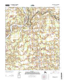
2013 Map of Fairbanks C-4 SE
USGS Topo · Published 2013About this map
The Tanana River dominates the northwest corner of this Interior Alaska landscape, serving as a primary hydrologic artery through the lowlands south of Fairbanks. The terrain is defined by a complex network of wetlands and shifting channels where the Wood River meanders across the central reaches of the map. This 2013 survey illustrates the wilderness at the border of the Fairbanks North Star and Yukon-Koyukuk census areas, showing how the smaller drainage of Tatlianika Cr feeds into the larger river systems. The absence of roads or permanent structures on this sheet underscores the remote nature of these river bottoms, which remain largely influenced by seasonal flooding and the natural migration of river bends over time.
Find a feature on this map
4 named features on this map. Tap any name to fly to it.
Don’t see what you’re looking for? This feature index may not catch every label — zoom into the map to look around manually.
Map Details
Editions of this 2013 Fairbanks C-4 SE Map
This is the sole edition of this map. No revisions or reprints were ever made.
Other maps of this area

1949 · Fairbanks B-4
USGS Topo · 1:63,360

1949 · Fairbanks B-3
USGS Topo · 1:63,360

1950 · Fairbanks
USGS Topo · 1:250,000

1950 · Fairbanks C-3
USGS Topo · 1:63,360

1950 · Fairbanks C-4
USGS Topo · 1:63,360

1951 · Fairbanks
USGS Topo · 1:250,000

1952 · Fairbanks C-4
USGS Topo · 1:63,360
1952 · Fairbanks B-4
USGS Topo · 1:63,360
1952 · Fairbanks B-3
USGS Topo · 1:63,360
1952 · Fairbanks C-3
USGS Topo · 1:63,360